Geographic Information Systems Center
Latest Launches
About The Center
The Geographic Information Systems Center is responsible for achieving effective integration between statistics and geographic information systems by building a smart interactive statistical system (geographical and statistical) . It allows to obtain indicators and information through a spatial statistical database supported by a smart statistical map. Today, geographic information systems considers the appropriate tool for studying phenomena, by linking place and data related to place (spatial phenomena) in a digital form that allows information to be deduced based on the data and statistics. It is one of the recent analyzes in the study of geographic information systems, especially those that deal with applications of digital modeling and simulation.
This center was one of the priorities of the agency’s leadership in Aden, as it was established since September 2021 due to the increasing importance and the necessity of benefiting from its outputs in mastering statistical work and reducing time, effort and cost in field statistical work by providing maps and samples and their locations on maps, as well as meet the increasing requests for maps from various parties. In addition to the organization’s publications, including books and bulletins.
Center Tasks
1- Establishing the infrastructure for the geographical information database in the organization , as following :
*Establishing a framework for geographic databases.
*Building standardization of geographic information.
*Create a geographic information structure.
* Establish a unified standard for data.
*Building technical capabilities that serve this field (training, education and practical experience).
2- Establishing and building the digital land of the country with all its administrative units on the computer screen ,so that it is possible to interact with it in a dynamic and semi-live manner.
3- Producing census, administrative and statistical maps, classifying them and saving them for use when implementing censuses and statistical surveys.
4-Developing geographic information systems (GIS) in the field of statistical maps in coordination with other relevant parties.
5- Contributing to the implementation of geographic information systems projects in the field of surveys and censuses and thus in development and planning according to the drawn up plans.
6- Supporting and raising the efficiency of the work of the Central Organization of Statistics in the field of surveys and census management.
7- Predicting and estimating statistical indicators using remote sensing techniques, such as field crop productivity, cultivated area, etc.
8- Designing the structure of geographical databases as following :
*Coordinating with the relevant departments in the agency to determine the information and data that will be included in the rule and determine priorities.
*Preparing a guide to administrative units, unified coding guides, and standardizing terminology in coordination with the relevant authorities and circulating them to data collection sources in the public, mixed, and private sectors.*Coordination with the Department of Processing and Automated Entry into the device and the calculator formations in the rest of the ministries and government institutions that are considered a source of database data to unify the names of variables related to spatial databases with the description of these variables.
9-Creating and managing an interactive portal for objective administrative and statistical maps via Internet.
10- Preparing proposals to design the general framework for administrative division, census, the unified general framework, and the privatized frameworks for the social, service, and other sectors.
11- Providing data and information related to the administrative and census division to all users inside or outside the agency and providing basic information about the various administrative units.
12-Providing satellite maps and visuals for field work.
13-Providing thematic maps.
14-Create an interactive electronic portal.
16- Utilizing GIS and remote sensing technology in statistical fields, such as helping to plan cities and study urban changes and the environmental system.
17-The ability to determine statistical sample sizes for various surveys.
18- Applying the appropriate methodology to select the sample for various surveys.
19-Calculating sample weights.
20- Following up changes that occur in administrative divisions through coordination with the Ministry of Local Administration and relevant authorities, providing the necessary information and data on the locations of ministries, facilities and institutions, and providing technical support in the following areas:
*Conduct a study and evaluation of the unification of methods for the frameworks currently available to serve statistical activities.
*Conduct a detailed study of databases using currently available frameworks and databases.
*Participate in the design and programming of systems in aspects related to administrative and census zoning data and basic data for establishment frameworks.
* Carry out analysis, inquiry, and reporting programs for the administrative and census divisions and various establishment frameworks
Center Departments
The Geographic Information system center consists of the following general departments .
1- General Administration of Maps .
2- General Administration for Remote Sensing .
3- General Administration of Frameworks .
4- General Administration of Samples.
Information Bank
Center Activities
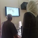
The Center supported many statisticsl works, as the Center participated during the previous period in the following surveys:
First: Food Security Survey 2021 & 2022 FSLA, in partnership with WFP, which conducted:
A- Drawing the primary sampling unit (clusters).
B- Training researchers to draw a sample of families in the field.
C-Supporting in producing maps.
Second: The Multiple Indicator Cluster Survey MICS6 2022-2023 in partnership with UNICEF, which drew a sample of selected households on the desk.
Third: Producing spatial and thematic maps.
Fourth: Conducting a study with a number of university academics and experts in the “field of remote sensing” on urban expansion in Aden Governorate.
Interactive Maps
Coming Soon
Contact Information

tamani.h@cso-ye.org

م. تماني حسن عبدالله محسن

009672204446